State College, April 3rd, 2012
Indoor Digital Wayfinding 2012
“Round Trip”
Wayfinding has been the domain of traditional static wayfinding signage since the beginning of times. “Has been”, as in the last decade, digital wayfinding for outdoor environments initiated a very successful new way of wayfinding. First in the form of a wayfinder device in the car, and well, we all know where Google it took ever since. Try to imagine a life without it.
Now, the digital wayfinding concept is entering the indoor wayfinding market. Because, if we like the convenience outside we would also appreciate it indoors right? Most likely yes, but the truth is, Digital Wayfinding for Indoor environments is like a whole new eco-system on the horizon and we have to learn to eat from it. Is it something for you? The following write-up will help you on your way.
Acceptance
Maybe the most important reason for the popularity of outdoor wayfinders is that it takes away our dependency. We can now figure it out ourselves. It makes us smarter. And having that service on a personal mobile device, only, lets say, triples that feeling. The outdoor wayfinding app is interactive, on-demand and at your fingertips.
So let’s see if Indoor Digital Wayfinding carries the same ingredients for getting very popular, right off the bat.
User (Visitor, Member, Staff, Patient, Student, etc)
Digital Indoor Wayfinding empowers the visitor to the building, by allowing them an ‘on-demand’ service to get routes inside the building, improving customer service. Users can get routes on-site through a touch screen or on a, anytime available, mobile application. Off-site, the (future) visitor can access the wayfinding application through the internet at home, print the routes (or send to mobile) and take along on their visit.
Facility Management
Digital Indoor Wayfinding also empowers the management of the building. Through an administrative system they can make updates to the wayfinding system themselves. Changes are uploaded and integrated instantly, helping them to keep better pace with the actual situation in the building. Imagine a class or department that moves locations. Or a Teacher/Doctor that moves offices. All an admin has to do is make these quick changes in the administrative application and the updates are live instantly across all devices.
So that is confirmed, Digital Indoor Wayfinding offers the same convenience and empowerment as Outdoor wayfinding.
Special Note
One big advantage of Digital Wayfinding for Indoor Environments deserves a paragraph of its own:
Fire services now have access to all the online floor plans of your building, on demand, on their own mobile, saving important minutes, if needed. They can even generate fastest routes.
Wayfinder Vs Wayfinding
The term ‘Wayfinder’ seems to have grown similarly connected with the Wayfinder we find in cars (sometimes incorrectly referred to as GPS). However, taken literally, the Digital Wayfinding System for indoor environments is a Wayfinder as well. And the Wayfinder in the car is, in turn, also a Digital Wayfinding System.
The wayfinder in the car can provide turn-by-turn directions, because it can use the GPS positioning system. It also has the road maps available, needed to provide both location and directional information.
Indoor Maps
Outdoor, everything is mapped out and stored in a large database (think of Google Maps) but indoor maps are not readily available for Indoor Wayfinding, let stand they are centrally stored in a database.
Indoor GPS
This GPS signal, and consequently the triangulation technology through satellites and phone towers, can’t be used indoors because the signal is weakened by the building structure, reducing it to unreliable signal strength and sometimes no signal at all. Besides, if it would properly penetrate the building, dealing with multi-floor environments would be a different challenge all together. Think about it.
A lot of good progress is made towards indoor position systems, through Wi-Fi, Bluetooth, RFID, Cell Phone tower triangulation, Indoor GPS amplifiers, etc, but none work reliable or are affordable enough to be useful for Indoor wayfinding. It will take years before we advance from the Research & Development platform to a widely accepted, affordable solution.
Outdoor Wayfinding: Maps + GPS = Turn-by-Turn directions
Indoor Wayfinding: (Reconstructed) Maps + No GPS = Point-to-Point directions
Point-to-Point directions
On a public indoor access point like an LCD touch screen, the directions are from the access point to the destination. The wayfinding application on the Web and Mobile provide any location to any location directions. Think about department to department, staff member to department, class room to bus stop, parking lot to address or building, etc.
Definition
Digital Interactive Wayfinding is finding directions, through the use of digital interactive media, such as a PC, mobile device, interactive kiosk or touch screen device (LCD/IPAD), by entering the start- and endpoint data into an interface, after which the (fastest) route is generated and displayed on the screen.
The displayed route can either be printed out or send to mobile.
Add “Indoor” to the mix, and the result is an Indoor Wayfinding system.
Tailored
When referred to an Indoor Wayfinding system in this document, it actually means a tailored digital wayfinding system. Any indoor wayfinding system has to be build from the ground up. This does mean that there is almost total freedom in deciding on the functionality and contents. Taking advantage of this, a good indoor wayfinding system will ultimately have a measurable, positive affect on the flow of people in the building and on the campus.
Primary function of a Wayfinding system
An Indoor Wayfinding system should supply indoor directions, be easy to use and display a clean interface. A first time user must clearly understand what its purpose is, and right after that, what is expected of him to get the desired results, all within a couple of seconds.
Minimum Features
- Multi-Lingual
- Multiple search options
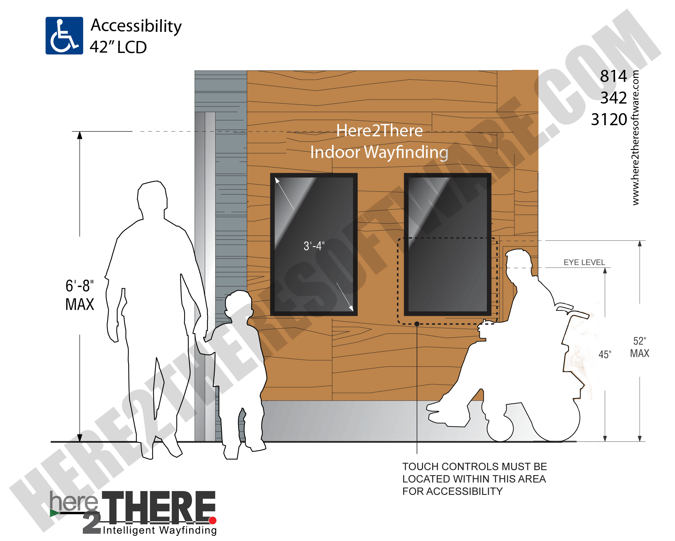
- Provide directions for everyone – including those with a mobility disability who require access routes.
- Directions in graphic and text
- Option to Print directions
- Option to Scan / Send directions to Mobile
- Accessible
- ADA
Digital Signage
On-site, the Wayfinding application is published on interactive displays and as such can be complimented with other content. Think about news, calendar and other useful content. All remotely to manage.
Since the display is interactive, other interactive applications can be integrated as well. Think about a room management system.
Wayfinding on your Web Pages
Temple University Wayfinding on the Web
With an, off-site, wayfinding system on the web, future visitors can preplan the visit in the comfort of their home. They can print out the routes or transfer it to their mobile and take it along.
Since the application is off-site, large Hospitals and other multi-building campuses can incorporate where to park in the route, when visiting a certain department. Very useful for visitors, making wayfinding on-site so much easier. One can even state that this would improve car park management, as cars will be parked more evenly over the available parking areas.
For that matter, issuing the route (including where to park) at the moment that the appointment is made by the referring office, looks like it might even more effective. Think about a Hospital and its referring doctors’ offices. And if the issued route is a link to the Online Wayfinding System, the route will still be the most current version, on the day of the appointment. Even if the department has changed location in the meantime.
Leading people to the right parking area will increase effectiveness in many areas. It doesn’t only make the visit so much easier, it also empowers the institute itself by regulating the flow all the way from entering the campus, attending the appointment, to leaving the premises.
Accessibility on the Web
The Wayfinding Application on the web also offers the opportunity of making it accessible for visual impaired visitors, by incorporating a text-only version. This in turn should work with JAWS (http://www.freedomscientific.com/) and similar screen readers.
United States: Web pages should be compliant to the accessibility guidelines of Section 508 (http://www.section508.gov/) and W3C (http://www.w3.org/).
Mobile Wayfinding
No, this doesn’t cost a gazillion dollars. Just don’t have a Wayfinding system made for each single mobile operation system, separately. Because nobody carries multiple mobile systems. Besides, the purpose is to make the wayfinding system as widely available as possible. Rather have one wayfinding system made, that will work on all operation systems (iPhone, Android, W7, Black Berry, Nokia, etc).
Yesterday, the reason for making a separate mobile app for each operating system was because it can do more and look better. But today, HTML 5 is here. No need to spend the extra dollars.
A mobile accessible wayfinding web page, is an affordable, reliable and centrally manageable, solution. But, most importantly, it is widely supported.
QR-codes

The use of QR codes increases the functionality and usability of Mobile Indoor Wayfinding. A good example is a QR code at the entrance of the building. The information stored in the QR code, in this case, could be as follows:
- Start Mobile Wayfinding Application (no app download)
- Get current map
- Show position on Map
Visitors can scan the QR code with their mobile (standard functionality on most smart phones) and they have the lay-out of the building and their position right on their mobile. All they have to do is select a destination from the Departments (or other) directory and the route is displayed.
Another practical use of the QR code in Indoor Wayfinding is on a Touch Screen when the requested route is being displayed. Here the QR code will trigger the following on the smart-phone:
- Start Mobile Application (again, no app download)
- Read generated route
- Publish route on Phone
Multiple QR signs inside the building will trigger to update the position on the map (on the Phone), closing in on offering the ultimate functionality of Indoor Turn-By-Turn directions, real nice.
Uses for Universities
Secure routes can be set, preventing the student to veer off the secured campus site into less safe zones.
- Alternate routes for students/visitors with disabilities, who need accessible routes.
- Assistance for visually impaired students/visitors to get around on the campus.
Other practical situations can be the one-click activation of:
- Move-in day routes
- Snow routes
- Sport event routes
People that will be using the Wayfinding application are:
- Parents picking up a sick kid
- Every day appointments
- A new member/student or indeed a seasoned member/student
Uses for Healthcare
Notoriously famous for always being under construction, there is no better way for Hospitals to keep their visitors informed, than through a Digital Wayfinding application.
Departments move, Physicians come and go and offices are always being added. A night mare if depending on static signage alone. Changes are made ‘live’ instantly, across all wayfinding platforms.
Because of all these changes, most older Hospitals are terrible to find your way around, period. I know of situations where elevators don’t stop on all floors or where each and every visitor is personally guided to their destination.
Next to eliminating the risk of raised anxiety levels of visitors, due to not knowing where they are and not knowing where they have to go, it also improves appointment schedules. If people don’t get lost in your building, they are better able to reach the appointment in time.
People that will be using the Wayfinding application are:
- Patients / Members
- Visitors
- Staff
- Every day appointments
Other Uses
[Image] [Image2] [Image3] [Image4] [Image5]
Trigger alternate routes automatically on scheduled times. Predefine Emergency routes. Routes to safety zones. Tours.
Integration with the stock, rental and location system of books (Library). Now the mobile can be used to see if a book is in, where it is located in the building and how to get to it (route).
Museums: Offering predefined routes based on interest. A click-to-hear feature to listen to a description of the painting or piece of art.
(Historical) Cemeteries: Routes to each individual grave. Tours. Provided with additional click-to-hear information.
Big Box stores: Routes to products. Incorporate the product information from the manufacturer, news, movie clips and coupons.
Automation is key
A good wayfinder application can calculate the fastest route based on the starting and end-point. Or the easiest route. Or preferred route. Or accessible route. Keyword is ‘calculate’.
Size of the project doesn’t matter. 5,000 locations? That is 5K*5K Point-to-Point directions. No problem.
Is a project, that big, still self-servicable? Yes, it is just as easy to manage as a small project.
Examples:
- A department moved? Just update Back-Office (Administrator program).
- An employee left to pursue other opportunities? Cancel him.
- New Staff member? Add him.
- Elevator broke down? Just disable it.
- Two-Way road turned into One-Way due to construction? Just click the road and select One-Way.
All routes will automatically update themselves with the new information.
Building it
An Indoor Wayfinding system pretty much has to be build from the ground up. Floor maps have to be reconstructed, the location of the hallways and destinations have to be programmed into the wayfinding application and a good administration program will have to be developed alongside, for self-service after delivery.
Wayfinding floor plans
In order for a floor map to be easy to decipher for the general public it has to be simplified and only include those items that matter.
-
Campus View: The buildings and roadways
-
Building view: Hallways and locations
-
Locations (Points of Interest)
-
Primary locations
-
Secondary locations
-
Legend
Primary Locations
These are locations where you want to provide directions to. Usually these are departments and/or staff. A user can request a route to these locations by either selecting one from a list (directory), click on the location on the map or search manually (with auto-complete).
The displayed primary locations depend on who the target audience is. “Do you want to offer this service for general wayfinding purposes only, or do you want to include staff-only accessible areas as well?”
Different access levels can be set up in a way that only the locations, which one is allowed to enter, will be displayed. This feature is probably foremost usable for government buildings where not everyone is ‘cleared’ to access everything.
Secondary Locations
General purpose areas where you don’t necessarily need to provide directions for, but do want to mention. Think about restrooms, emergency exits, fire extinguishers, elevators, stair wells, coat check, first aid, etc.
These locations will be marked on the map and described in the Legend.
Hybrid locations overlap this logic. One can search for them and they are marked on the map. Example: key-locations such as reception, check-in, concierge, business center services, security, etc. However, to keep any floor plan clean and easy on the eyes, don’t go overboard here.
Wayfinding Interface
The floor maps are done, the locations are defined and navigation logic is set. Now the design of the interface can begin. The customer needs to supply the company logo, preferred fonts and color wheel. The looks of the interface has to be consistent with the format guidelines of the company.
Wayfinding Navigation
The more search options offered to get the desired route, the better. A directory, interactive map and manual search (with auto-complete) are the options available. Use them all.
Conclusion
Digital Wayfinding can improve many areas and if you are in charge of wayfinding for your building, or if you manage the patient flow, or are in charge of increasing accessibility services for your campus, this may very well be something for you. It will take a lot of effort on both sides to make a fitting solution, but it will pay off.
You know you need a digital indoor wayfinding system, if you need to guide patients from check-in to the destination, because the route is too complicated.
If you plan to make some major revisions to your building and or campus, and a lot of departments need to relocate temporarily, Digital Wayfinding will be a saving grace.
“Our premises is just too large to know where everything is at all times”
“The current layout of our building/campus is just too confusing for visitors”
“Our buildings are old and the accessible entrances are different from the standard ones”
“We want to improve accessibility in our building/on our campus”
“People try to get on the escalator while on a wheel chair (It happened, it’s true)”
Apart from the last statement, of which it is questionable if there is anything that could help in these situations, the other signs are a definite ‘tell’ to look into indoor digital wayfinding.
support@here2theresoftware.com
www.here2theresoftware.com
© Copyright 2012 Global Software Applications, LLC


![[image]](/uploads/2011/11/H2T_Liberty_U_Lg.png)
![[Image]](/uploads/2011/08/Garf_Steps_Large1.png)
![[Image2]](/uploads/2011/08/H2T_Hospital_Additional_Signage_Pages1.png)
![[Image3]](/uploads/2011/08/H2T_Susquehanna1.png)
![[Image]](/uploads/2011/08/H2T_NewBrighton_Church_Lg1.png)
![[Image2]](/uploads/2011/08/H2T_Corporate_Steps_Lg1.png)
![[Image3]](/uploads/2011/08/H2T_Govt_Building_Steps_Lg2.png)
![[Image4]](/uploads/2011/08/H2T_Holden_High_Lg1.png)
![[Image5]](/uploads/2011/08/H2T_State_Government_Steps_Lg1.png)
![[Image]](/uploads/2012/04/H2T_Floorplan_Breakdown_Process.png)